


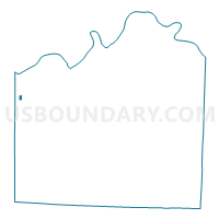
KC WD4 PCT404, Jackson County, Missouri
About
Outline

Summary
| Unique Area Identifier | 608421 |
| Name | KC WD4 PCT404 |
| County | Jackson County |
| State | Missouri |
| Area (square miles) | 0.13 |
| Land Area (square miles) | 0.13 |
| Water Area (square miles) | 0.00 |
| % of Land Area | 100.00 |
| % of Water Area | 0.00 |
| Latitude of the Internal Point | 39.06074520 |
| Longtitude of the Internal Point | -94.59283040 |
Maps


Graphs
Select a template below for downloading or customizing gragh for KC WD4 PCT404, Jackson County, Missouri


Neighbors
Neighoring Voting District (by Name) Neighboring Voting District on the Map
- KC WD1 PCT109, Jackson County, MO
- KC WD4 PCT403, Jackson County, MO
- KC WD4 PCT405, Jackson County, MO
- KC WD5 PCT503, Jackson County, MO
- KC WD5 PCT504, Jackson County, MO
- KC WD5 PCT509, Jackson County, MO